|
||||||||||
|
|
||||||||||
|
||||||||||
|
|
||||||||||
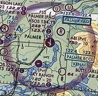
Compare these symbols with those used for the large airports at Anchorage and Elmendorf Air Force Base that are illustrated below. These long runways are depicted using thick boxy outlines rather than any form of circle.

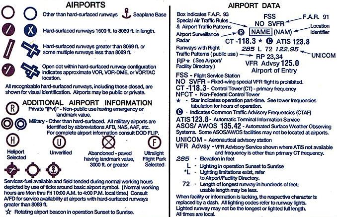
The legend shown below provides further explanation of these symbols. For example, it indicates that runways using the circular symbol are between 1,500 and 8,069 ft in length while runways longer than 8,069 ft use the boxy outline symbol. Furthermore, the legend describes how to determine the longest runway at a given airport. In our examples, the longest runway at Palmer is 6,000 ft while those at Anchorage and Elmendorf are 10,900 ft and 10,000 ft, respectively.
An explanation for the magical number 8,069 ft was found at the official website of the National Aeronautical Charting Office, or NACO. NACO is a section of the Federal Aviation Administration (FAA) that is responsible for maintaining aviation system standards. NACO's primary duty is to publish and distribute US government civil aeronautical charts and flight information publications. These materials are vital for pilots to properly and safely navigate the skies.
According to the NACO site, runways over 8,069 ft are depicted differently than shorter runways simply because of limitations in the symbology available to the map makers. The exact quote from NACO is as follows:
"For purposes of airport depiction, when a runway is between 7970 and 8069 feet in length NACO cartographers round to 8000 which equates to a line 0.192 inches in length on the Sectional chart scale. In this case a circular aerodrome symbol is used. If the runway is between 8070 and 8169 feet in length, cartographers round to 8100 which equates to a line 0.1944 inches in length on the Sectional chart scale. This line is simply too long to fit into the largest circular aerodrome symbol NACO has available. Therefore, when an airport has a runway that is greater than 8069 feet in length cartographers place a box around the runway pattern forming an enclosed shape."As you can see, the explanation is rather anti-climactic. There is nothing terribly significant about the value 8,069 ft itself, but it is the length of the runway in the scale of the chart that is the limiting factor. If the map makers had the means to enclose long runways in a larger circle, they'd almost surely do so.
Read More Articles:


|
Aircraft | Design | Ask Us | Shop | Search |
|
|
| About Us | Contact Us | Copyright © 1997- | |||
|
|
|||